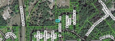
DOQQ maps or Digital Orthophoto Quandrangle maps are created from aerial photos, which are geometrically altered so they can be used as a map. The photos are often used in GIS software (Geographic Information System). I have linked to the Citrus County (Florida) Property Appraiser's Web site, which uses a GIS system to map all properties in the county. The software allows the user to place lines, text and symbols atop the photos. You can zoom in far enough to see the rooftops of homes or out far enough that shows a PLSS (Public Land Survey System) of Citrus County. The image I have linked to is one magnification from the maximum and shows my neighborhood. My home is outlined in light blue. Florida Avenue is U.S. 41. The Withlacoochee Trail follows the Withlacoochee River for nine miles.
Here is a link to the Web site. The map resets, so to view the area pictured above interactively, visit the following Web site and search for "Arnold Michael."


No comments:
Post a Comment